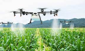
AGRICULTURE
MAPPING
SURVELLIANCE
CARGO
SEARCH RESCUE
HOMELAND
How high can an agricultural drone fly?
Under the Indian laws permissible limits for the Drones fly is 400 ft in the Indian skies
2. Is any special licence required to fly agricultural drones?
Yes a training certificate from a DGCA recognized training Institute is mandatory to fly Drones above 25 kg and only if flying commercially then for the 2 kg to 2 kg (Micro Category) is also required, flying agricultural drones depends on national laws. Nonetheless a training is normally required.
3. What are the best weather conditions to fly a drone over a field?
A drone can fly under any weather condition. If Drones are water resistant, but
image quality can be damaged if pictures are taken during rainy weather.
4. What distances can agricultural drones fly?
It depends on the drone capability and size. Fixed wings drones have longer flight
time and can cover more field in one flight. For instance, 50 min flight time will cover up to 12km2
.
5. What makes the difference between images taken by a drone and satellite images?
Drones can take pictures with a resolution down to a few cm per pixel. A drone can get higher quality and higher
precision of images in real time as they can fly below the clouds. Besides, a satellite only takes pictures once a
week or once a month.
6. What kind of information can farmers get from the images?
Raw data collected by drones gets translated into useful and comprehensible information for farmers thanks to
specific algorithms. Some of the information these images provide is:
Plant counting: plant size, plot statistics, stand number, compromised plots, planter skips),
Plant height: crop height and density
Vegetation indices: leaf area, anomaly detection, treatment efficacy, infestations, phenology
Water needs: damage/drown out
Drones ensure a permanent monitoring of the crop in the field from planting to harvest.
7. What are the main benefits farmers can get from the use of ag drones?
Drones can help farmers to optimize the use of inputs (seed, fertilizers, water), to react more quickly to threats
(weeds, pests, fungi), to save time crop scouting (validate treatment/actions taken), to improve variable-rate
prescriptions in real time and estimate yield from a field.
8. What are the advantages of combining smart agricultural machinery and agricultural drones?
As of today, drones cannot communicate directly with agricultural equipment. Drones fly over the field and take
high resolution pictures. The data gathered is directly sent to the cloud/software and made available to the
customer. Thanks to this data, the user can select the information wanted from the images and make different
prescription maps depending on the operation the farmer wants to perform on the field. The maps can then be
uploaded on the farm equipment which will adjust the amount of inputs (seeds, fertilizers, pesticides) that would
need to be applied in the field accordingly.
9. What are the expectations for this market to grow in the coming years?
It is expected that the use of drones will grow significantly in farming as they offer a wide range of applications to
improve precision agriculture.
10. How much does an agricultural drone cost?
A standard drone for public use starts at Rs.400000/- Onwards but may vary as per the attachements and payloads